
Journal articles
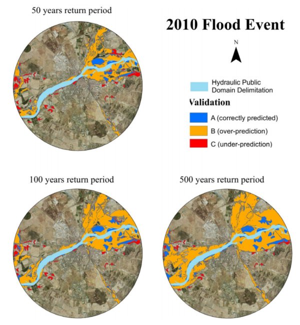
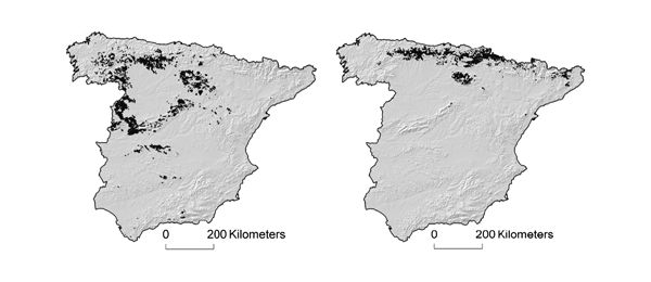
Flood risk maps delineate areas potentially at risk of flooding and are thus a crucial tool in flood risk management. In Spain, such maps are provided as open geospatial data. This article compares the flood‐prone areas according to those maps for floods of different return periods with the spatial extent of two floods that severely affected southwestern Spain using open source optical and radar satellite imagery. Results using the recall metric were found to be very good and are the most relevant to emergency preparedness services as this metric focuses on the correctly predicted flooded areas. It was also found that the 500‐year flood risk map was the one with the best precision and accuracy for both flood events. The results confirm the accuracy of the flood risk maps based on open source remote sensing imagery and hence demonstrate the potential of publicly available and freely distributed remote sensing data in their development.
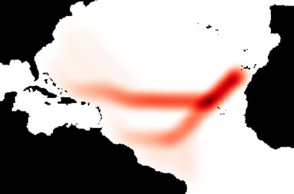
La ruta seguida por la primera expedición de Cristóbal Colón es incierta debido a la ausencia o poca fiabilidad de esta información en el diario del almirante. Los actuales datos procedentes de teledetección y su análisis mediante SIG pueden aportar nueva información mediante análisis de los campos de viento estacionales en la zona. Los resultados del análisis de seis años muestran que el régimen de vientos es homogéneo y que configura dos corredores o pasillos de bajo coste relativo para la navegación a vela con las condiciones de los barcos del siglo XV. De estos dos corredores uno conduce con exactitud al destino al que se cree que llegó Colón el 12 de octubre de 1492 y se presenta como la ruta más probable, algo más al Sur que la propuesta hasta el presente en la bibliografía. Los SIG se muestran como una herramienta capaz de aportar información inédita a partir de datos globales, tomados en este caso por el escaterómetro QuikSCAT, aplicando métodos de análisis espacial poco usados en la literatura científica.
https://doi.org/10.1016/j.jasrep.2020.102312.
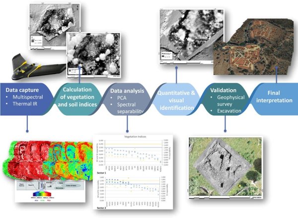
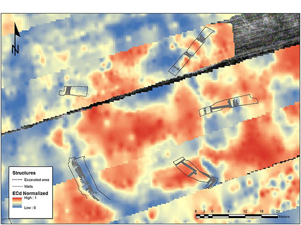
In recent years, the miniaturization of remote sensing equipment and the striking improvement of UAV technology has provided a new, high-resolution view of archaeological sites beyond the visible spectrum. This work explores the potential of low altitude remote sensing (multispectral and thermal infrared imaging) for the study of complex archaeological zones through the study case of an Iron Age hillfort in the southwest of the Iberian Peninsula. We describe the methodology developed in order to maximize and objectively quantify the detection of buried structures. On the one hand, we evaluate the capacity to categorize the response to varying depths of the overlying sediments, exploring the limits of the statistically significant separability between noise and signal. On the other hand, thermal IR images taken at different times of the day are compared to assess the optimal conditions for the identification of archaeological features. The results reveal that although we can only approach meaningful separability values, it was possible to identify a large number of buried structures. These results were finally validated by comparison with the data obtained by geophysical survey and excavation.
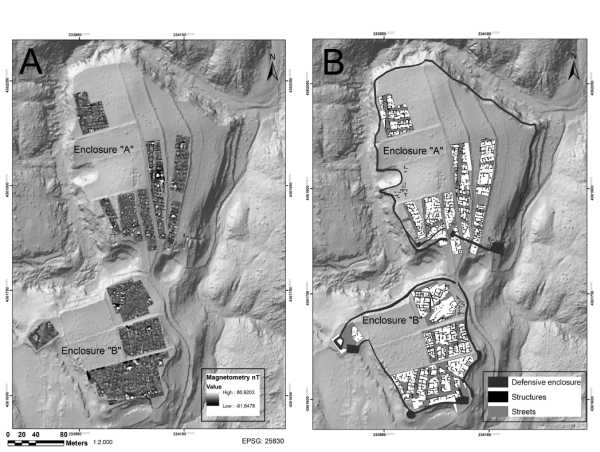
El objetivo de este trabajo es proporcionar un primer avance del estudio del castro de Villasviejas del Tamuja (Botija, provincia de Cáceres) a partir de la combinación de técnicas no destructivas. La posibilidad de cruzar los resultados obtenidos con diversos métodos geofísicos (magnetometría, georradar y tomografía eléctrica) plantea la oportunidad de formular un diagnóstico fiable sobre la organización espacial de este enclave.Se describen los resultados más relevantes, y se valora su aportación para una interpretación general de la estructura urbana y la morfología de los espacios domésticos. Esta información es contrastada con los datos de excavación previamente disponibles, y se analiza su encuadre dentro del conocimiento actualmente existente sobre este tipo de asentamientos. Asimismo, se añaden elementos de interés acerca de la evolución diacrónica del sitio, que son relevantes en relación con las hipótesis formuladas acerca del impacto de la conquista romana.En última instancia se pondera el potencial de este tipo de estrategias de investigación para el estudio y revalorización de zonas arqueológicas grandes y complejas.
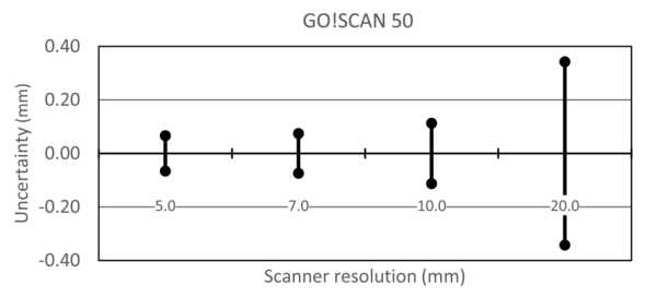
Polo, María-Eugenia, Cuartero, Aurora, Felicísimo, Ángel M. (2019) Study of uncertainty and repeatability in structured-light 3D scanners. arXiv.org – Electrical Engineering and Systems Science – Image and Video Processing: 9 pp. https://arxiv.org/abs/1910.13199
Structured-light 3D scanners create 3D models with high accuracy, but controlling the accuracy and repeatability of the scanner is essential. The objective of this paper is to analyze the repeatability and accuracy of two structured-light 3D scanners (Go!SCAN 20TM and Go!SCAN 50TM). The method used scans steel gauge blocks several times with different resolutions to analyze the scanned data and to test the correlation between uncertainty, resolution, and scanner model. The primary results include: 1) a systematic error of magnitude similar to nominal accuracy exists and must be corrected and 2) the global uncertainty is approximately 0.05 mm without significant differences between the two scanner models. A strategy for scanning is proposed based on the results at different resolutions.
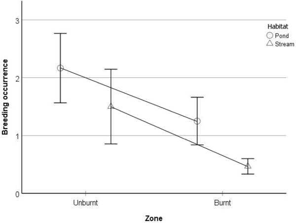
Muñoz, Alberto; Felicísimo, Ángel M.; Santos, Xavier. Assessing the resistance of a breeding amphibian community to a large wildfire. Acta Oecologica (publicado online en junio de 2019). DOI: 10.1016/j.actao.2019.06.002
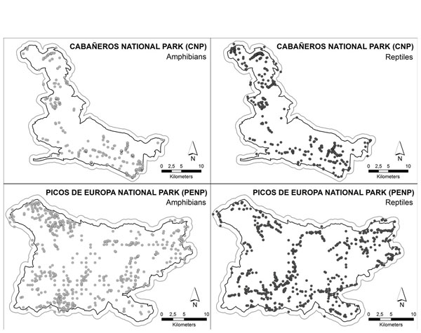
Socioeconomic and global climate changes are modifying fire regimes towards larger and more intense fires. Studying the response of organisms to the occurrence of large fires is crucial to anticipate shifts in patterns of biodiversity in fire-prone regions. Amphibia is the most threatened terrestrial vertebrate taxon, although it is also the least studied in relation to its response to fire. We evaluated the resistance to fire (similarity in species composition before and after fire) and reproductive success during the first breeding season after a fire of an amphibian community at the Mediterranean basin. We sampled 33 aquatic habitats, including ponds and streams located inside and outside the perimeter of the fire, and reported the presence of adult amphibians and their reproductive success. The community composition in burnt and unburnt areas was compared by similarity analysis. Generalized Linear Models were used to test the effects of fire (burnt or unburnt area), habitat type (stream or pond), distance to the perimeter of the wildfire, and altitude on total and breeding species richness. We did not find significant differences in amphibian community composition between burnt and unburnt areas, or in total species richness per water point. Of the 12 species found in the study area, only frogs of the genus Hyla declined in the burnt area due to the destruction of their preferred microhabitat, i.e. vegetation surrounding ponds. In contrast, breeding occurrence and breeding species richness declined in burnt streams and ponds. These results suggest a high amphibian resistance to fire at the community level, although the reduction of breeding activity can threaten the persistence of a rich community in future scenarios of increased recurrence of megafires.
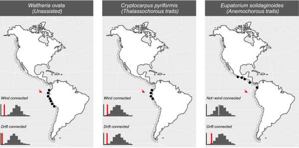
Javier, Fajardo; Mateo, Rubén G.; Vargas, Pablo; Fernández Alonso, José; Gómez-Rubio, Virgilio; Felicísimo, Ángel; Muñoz, Jesús (2019) The role of abiotic mechanisms of long-distance dispersal in the American origin of the Galápagos flora. Global Ecology and Biogeography (IF: 5.95), 28(11): 1610-1620. DOI: 10.1111/geb.12977
Long‐distance dispersal research in plants has long been dominated by the assumption that an association between plant diaspore adaptations and related transport vectors (standard dispersal) determines the success of colonization. However, the role of diaspore adaptations in a biogeographic context is being increasingly questioned, as evidence reveals that unspecialized plants have been successful colonizers by recurrent non‐standard dispersal. We studied wind and oceanic currents as vectors for long‐distance plant dispersal between the Americas and the Galápagos Islands with the focus on diaspore specializations to gain knowledge on the net contribution of standard and non‐standard dispersal mechanisms.
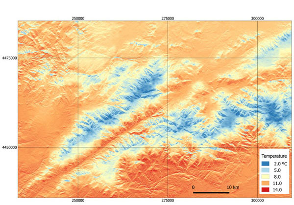
Abstract: Climate maps have been widely used for the construction of species distribution models. These maps derive from interpolation of data collected by meteorological stations. The sparse distribution of stations generates maps with coarse spatial resolution that are unable to detect microclimates or areas that can serve as plant or animal refuges. This work proposes a method for downscaling temperature maps using the solar radiation falling upon hillsides as predictor for the influence of relief on local variability. Solar irradiance is estimated from a digital elevation model of the study area using a routine based on analytical hillshading. Some examples of downscaling from 1 km to 25 m spatial resolution are shown. The results are compared with the surface temperature maps from Landsat 8 satellite imagery.
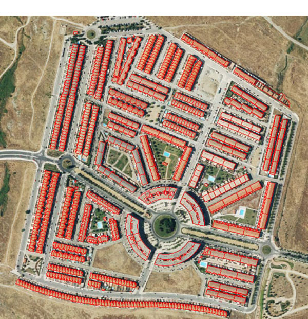
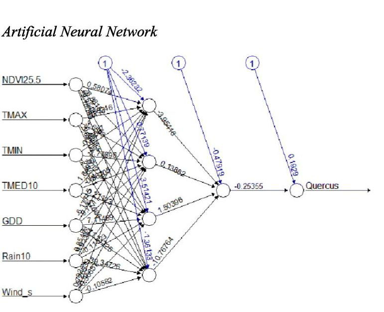
Techniques of remote sensing are being used to develop phenological studies. Our goal is to study the correlation among the Normalized Difference Vegetation Index (NDVI) related with oak trees included in three set data polygons (15, 25 and 50 km to aerobiological sampling point as NDVI-15, 25 and 50), and oak (Quercus) daily average pollen counts from 1994 to 2013. The study was developed in the SW Mediterranean region with continuous pollen recording within the mean pollen season of each studied year. These pollen concentrations were compared with NDVI values in the locations containing the vegetation under a study based on two cartographic sources: the Extremadura Forest Map (MFEx) of Spain and the Fifth National Forest Inventory (IFN5) from Portugal. The importance of this work is to propose the relationship among data related in space and time by Spearman and Granger causality tests. 9 out of 20 studied years have shown significant results with the Granger causality test between NDVI and pollen concentration, and in 12 years, significant values were obtained by Spearman test. The distances of influence on the contribution of Quercus pollen to the sampler showed statistically significant results depending on the year. Moreover, a predictive model by using Artificial Neural Network (ANN) was applied with better results in NDVI25 than for NDVI15 or NDVI50. The addition of NDVI25 with the lag of 5 days and some weather parameters in the model was applied with a RMSE of 4.26 (Spearman coefficient r = 0.77) between observed and predicted values. Based on these results, NDVI seems to be a useful parameter to predict airborne pollen.
The image-based modelling systems create 3D models of objects using a set of overlapping photographs. Several applications are available that do not require a user expert or expensive equipment. In this paper, four free systems were applied in two cases: ReMake, which is a freemium software, CMP Web Service and Arc 3D, which are free web services, and Visual SfM, which is a free software. The purpose of this study is to evaluate the applications that support topographical measurements and to assess the potential for their use in accurate modelling. The results show that these systems can be an auxiliary technique for surveyors and can provide an advantage in some cases
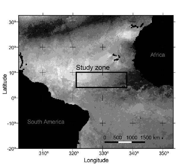
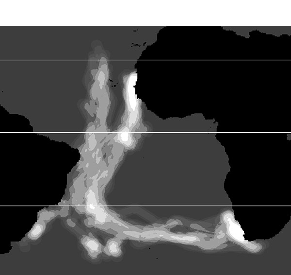
Circular or directional data are used in disciplines such as meteorology, geomatics, biology, and geology. The analysis of angular data requires special methods that are available in some statistical packages. However, these tools analyze only the angular values and do not include the vector modules, assuming unit vectors in all cases. In this letter, an open-source graphic and statistical package, i.e., VecStatGraphs2D, is described. It works in the R environment and provides statistics and graphics for modules (linear) and azimuths (circular), as well as graphics for the joint analysis of modules and azimuths. QuikSCAT satellite wind data are used to demonstrate some features of the package. QuikSCAT data are non-unit-length vectors, where both azimuth and magnitude (speed) are derived from u and v vector components (vector projections over the x- and y-axes). The example is used to show the seasonal change of winds in the Intertropical Convergence Zone, a key area in the ocean bird migration from the North to South Atlantic oceans.
La sismicidad de la región Ibero-Mogrebí (RIM) se caracteriza por la ocurrencia de grandes terremotos separados por largos intervalos de tiempo. La frecuencia con que ocurren estos grandes sismos varía, siendo mayor en el este de la región (Argelia) y menos frecuentes aunque de mayor tamaño en el oeste (cabo de San Vicente). En el volumen, 29 de Física de la Tierra se ha querido recopilar la información existente de los grandes terremotos ocurridos en esta zona y los daños que han ocasionado.

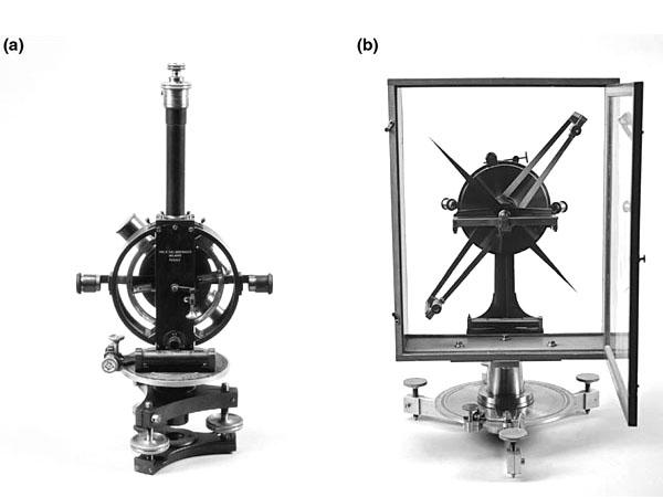
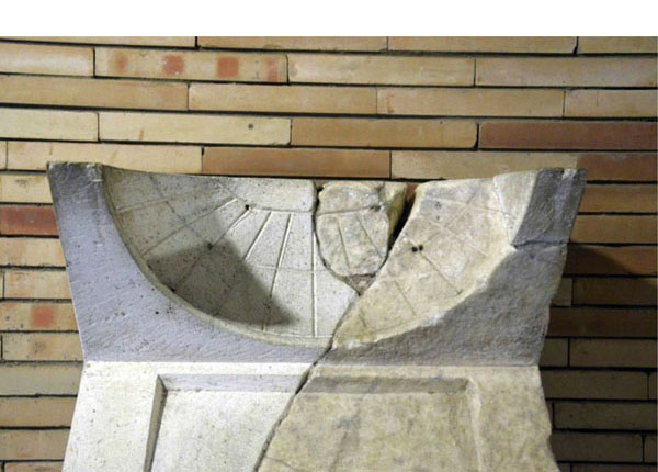
Abstract: Three-dimensional (3-D) models of archaeological artifacts can be obtained using free or low-cost image-based modeling (IBM) systems. IBM systems generate a 3-D model by processing a set of overlapping digital photographs of an object or scene. Sundials are generally located in inaccessible places, and photography may be the only method to study them. The purpose of this paper is to explore the potential of the 3-D modeling of archaeological objects obtained by IBM systems and embedded in a 3-D interactive portable document format (PDF) file. The process is illustrated by two case studies: a Roman sundial and a historical vertical sundial. The 3-D interactive PDF file allows for measuring some elements in the 3-D model. These measurements can be obtained easily and provide metric information about the sundials without touching them.
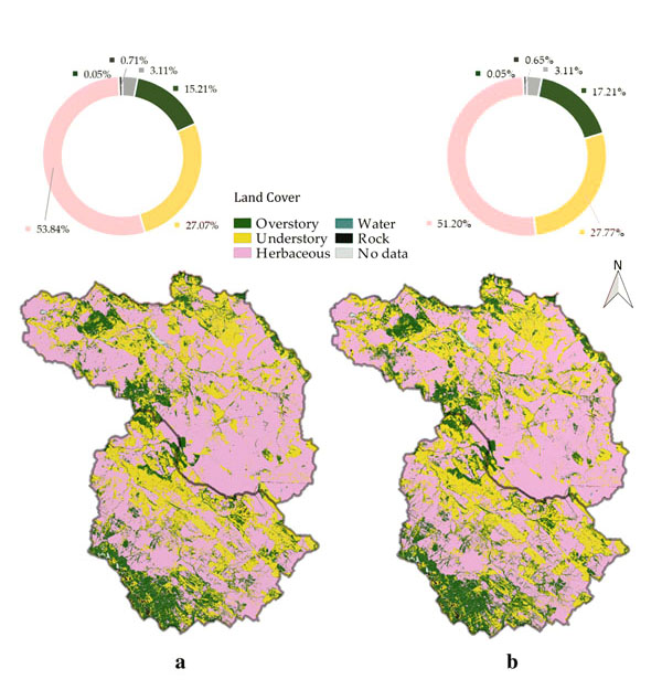
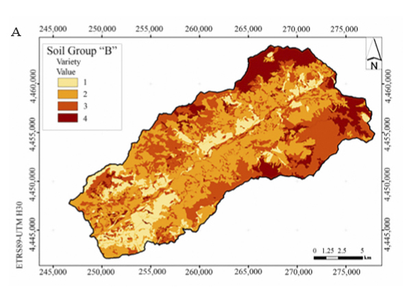
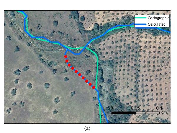
Aim of study: The goal of this study is to analyse variations in curve number (CN) values produced by different cartographic data sources in a forested watershed, and determine which of them best fit with measured runoff volumes. Area of study: A forested watershed located in western Spain. Material and methods: Four digital cartographic data sources were used to determine the runoff CN in the watershed. Main results: None of the cartographic sources provided all the information necessary to determine properly the CN values. Our proposed methodology, focused on the tree canopy cover, improves the achieved results. Research highlights: The estimation of the CN value in forested areas should be attained as a function of tree canopy cover and new calibrated tables should be implemented in a local scale.
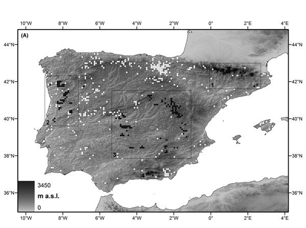
A large amount of data for inconspicuous taxa is stored in natural history collections; however, this information is often neglected for biodiversity patterns studies. Here, we evaluate the performance of direct interpolation of museum collections data, equivalent to the traditional approach used in bryophyte conservation planning, and stacked species distribution models (S‐SDMs) to produce reliable reconstructions of species richness patterns, given that differences between these methods have been insufficiently evaluated for inconspicuous taxa. Our objective was to contrast if species distribution models produce better inferences of diversity richness than simply selecting areas with the higher species numbers. As model species, we selected Iberian species of the genus Grimmia (Bryophyta), and we used four well‐collected areas to compare and validate the following models: 1) four Maxent richness models, each generated without the data from one of the four areas, and a reference model created using all of the data and 2) four richness models obtained through direct spatial interpolation, each generated without the data from one area, and a reference model created with all of the data. The correlations between the partial and reference Maxent models were higher in all cases (0.45 to 0.99), whereas the correlations between the spatial interpolation models were negative and weak (−0.3 to −0.06). Our results demonstrate for the first time that S‐SDMs offer a useful tool for identifying detailed richness patterns for inconspicuous taxa such as bryophytes and improving incomplete distributions by assessing the potential richness of under‐surveyed areas, filling major gaps in the available data. In addition, the proposed strategy would enhance the value of the vast number of specimens housed in biological collections.
Texto completo en http://www.geofocus.org/index.php/geofocus/article/view/432
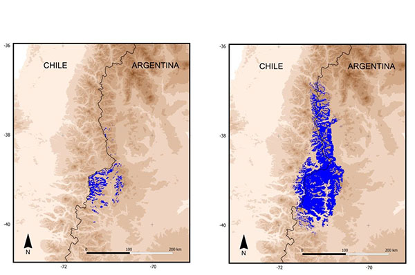
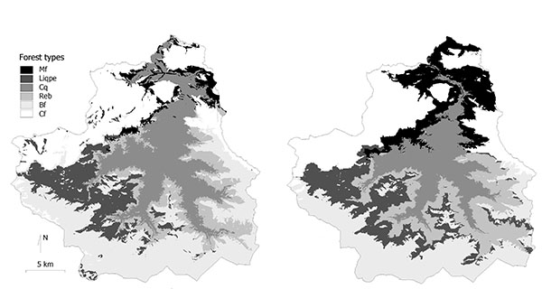
La Cordillera de los Andes es una de las regiones de mayor biodiversidad del mundo. En las próximas décadas, sus ecosistemas pueden verse afectados por el cambio climático global de forma más o menos intensa. El objetivo de este trabajo es realizar estimaciones de esos cambios en los principales sistemas forestales de la región. Para ello se analiza la distribución actual de los bosques y se utilizan métodos de modelado predictivo para de delimitación de las áreas de distribución potenciales actuales y futuras. Se consideran tres escenarios diferentes bajo el modelo global CCCma. Los resultados muestran los cambios previstos en el área de distribución de forma tabular y cartográfica. Los bosques se ven afectados negativamente de forma general aunque hay algunas excepciones bajo algunos escenarios. Se discute la interpretación de los resultados y las incertidumbres que afectan a este tipo de modelos.
Texto completo en https://www.researchgate.net/publication/277019769_FORCLIM_impacto_del_cambio_climatico_en_los_bosques_iberomericanos
FORCLIM es el acrónimo de la «Red Iberoamericana para el estudio de ecosistemas forestales ante el cambio climático global», formada por grupos de seis países e integrado en las acciones promovidas por el programa CYTED (Ciencia y Tecnología para el Desarrollo). FORCLIM se desarrolló en el periodo 2009-2012 con el objetivo consolidar métodos y difundir técnicas para la modelización del impacto del cambio climático en la distribución de los bosques. Al final de su desarrollo, se ha llegado a la consolidación de una línea de trabajo con métodos estandarizados que permiten abordar por cualquier grupo u organización los análisis básicos sobre el tema principal de la Red. En este artículo se presenta un resumen del trabajo realizado incluyendo una explicación de la metodología, una muestra de los resultados y una discusión sobre ventajas y problemas del método propuesto.
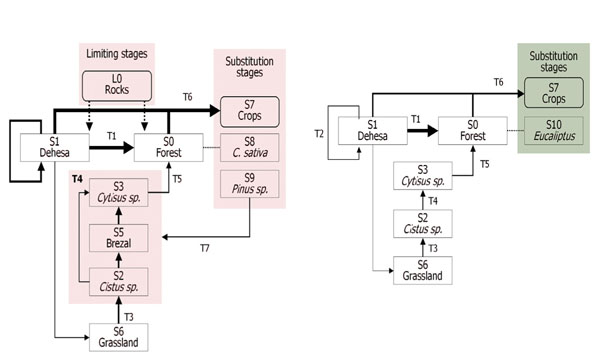
Aim of study: In this study a process based on a Geographic Information System (GIS) is proposed as a tool for analyzing the spatial structure of the Mediterranean dehesa ecosystem.
Area of study: Western Peninsular Spain.
Material and methods: The method allows a semi-quantitative “state and transitions” (S&T) net that provides original information derived from spatial patterns that cannot be obtained by other means.
Main results: This GIS analysis also supplies a spatial basis which complements the conceptual framework of vegetation series successional proposals. Moreover, the proposed method can be a useful tool for understanding landscape changes.
Research highlights: Our work proposes not only a descriptive model but also a methodology based on spatial metrics and topological relationships.
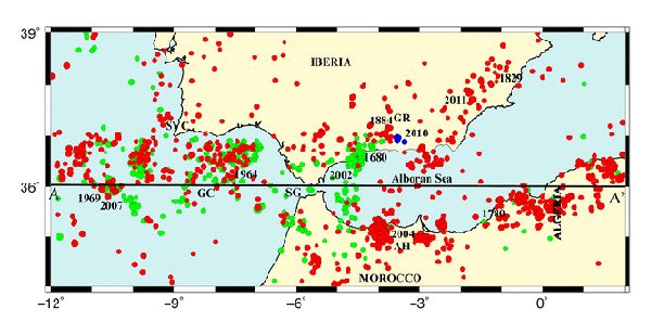
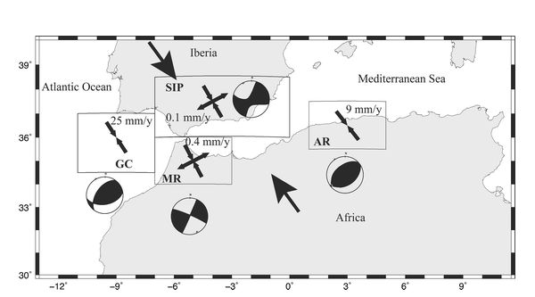
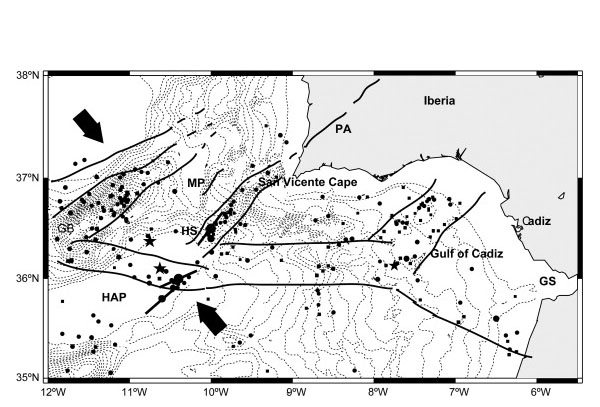
Large earthquakes (Mw>6, Imax>VIII) occur at the Ibero-Maghrebian region, extending from a point (12 ºW) southwest of Cape St. Vincent to Tunisia, with different characteristics depending on their location, which cause considerable damage and casualties. Seismic activity at this region is associated with the boundary between the lithospheric plates of Eurasia and Africa, which extends from the Azores Islands to Tunisia. The boundary at Cape St. Vincent, which has a clear oceanic nature in the westernmost part, experiences a transition from an oceanic to a continental boundary, with the interaction of the southern border of the Iberian Peninsula, the northern border of Africa, and the Alboran basin between them, corresponding to a wide area of deformation. Further to the east, the plate boundary recovers its oceanic nature following the northern coast of Algeria and Tunisia. The region has been divided into four zones with different seismic characteristics. From west to east, large earthquake occurrence, focal depth, total seismic moment tensor, and average seismic slip velocities for each zone along the region show the differences in seismic release of deformation. This must be taken into account in developing an EEWS for the region.
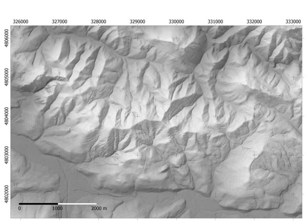
In-situ environmental parameter measurements using sensor systems connected to a wireless network have become widespread, but the problem of monitoring large and mountainous areas by means of a wireless sensor network (WSN) is not well resolved. The main reasons for this are: (1) the environmental variability distribution is unknown in the field; (2) without this knowledge, a huge number of sensors would be necessary to ensure the complete coverage of the environmental variability and (3) WSN design requirements, for example, effective connectivity (intervisibility), limiting distances and controlled redundancy, are usually solved by trial and error. Using temperature as the target environmental variable, we propose: (1) a method to determine the homogeneous environmental classes to be sampled using the digital elevation model (DEM) and geometric simulations and (2) a procedure to determine an effective WSN design in complex terrain in terms of the number of sensors, redundancy, cost and spatial distribution. The proposed methodology, based on geographic information systems and binary integer programming can be easily adapted to a wide range of applications that need exhaustive and continuous environmental monitoring with high spatial resolution. The results show that the WSN design is perfectly suited to the topography and the technical specifications of the sensors, and provides a complete coverage of the environmental variability in terms of Sun exposure. However these results still need be validated in the field and the proposed procedure must be refined.
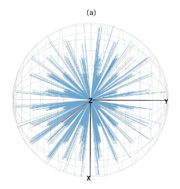
The use of spherical statistics for comparing and analyzing different digital elevation models (DEMs) is proposed in this letter by the new software package VecStatGraphs3D. Spherical data deal with angular data such as unit vector in 3-D space and are used in disciplines such as meteorology, geomatics, biology, and geology. Usually, the most common descriptor to analyze DEMs is the root-mean-square error (linear statistic), but this statistic itself cannot describe the error positional distributions. Comparing homologous points in two different DEMs generates 3-D vectors, which can be analyzed by means of spherical statistics. A 3-D vector is defined by its module (linear statistics) and colatitude and longitude (spherical statistics). While several graphical and statistical tools are available for the analysis of directional data in 3-D, these tools consider only the angular magnitude and work with unit vectors. In this letter, the open-source software package VecStatGraphs3D is described. It works in the R environment and provides statistics for modules (linear), colatitude and longitude (spherical), and graphics for the joint analysis of 3-D vectors. The spatial locations of singular points between two DEMs of different spatial resolution: LIDAR (5 m) and ASTER Global Digital Elevation Map (30 m) are compared as examples using VecStatGraphs3D. The interactive 3-D graphics reveal spatial patterns and assist in understanding the effect of the DEM resolution on the uncertainty of the spatial locations of relief.
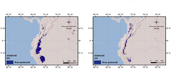
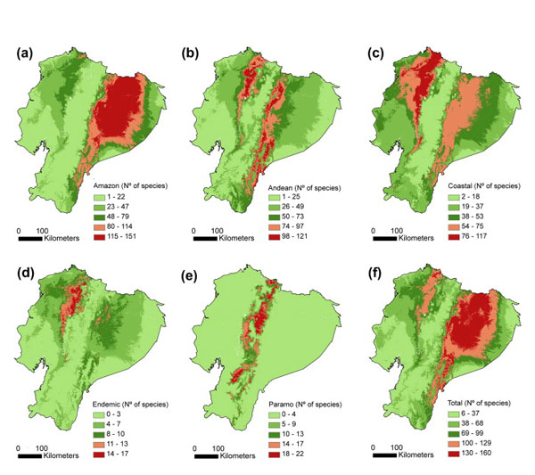
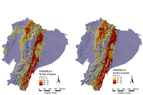
Knowledge about spatial biodiversity patterns is a basic criterion for reserve network design. Although herbarium collections hold large quantities of information, the data are often scattered and cannot supply complete spatial coverage. Alternatively, herbarium data can be used to fit species distribution models and their predictions can be used to provide complete spatial coverage and derive species richness maps. Here, we build on previous effort to propose an improved compositionalist framework for using species distribution models to better inform conservation management. We illustrate the approach with models fitted with six different methods and combined using an ensemble approach for 408 plant species in a tropical and megadiverse country (Ecuador). As a complementary view to the traditional richness hotspots methodology, consisting of a simple stacking of species distribution maps, the compositionalist modelling approach used here combines separate predictions for different pools of species to identify areas of alternative suitability for conservation. Our results show that the compositionalist approach better captures the established protected areas than the traditional richness hotspots strategies and allows the identification of areas in Ecuador that would optimally complement the current protection network. Further studies should aim at refining the approach with more groups and additional species information.
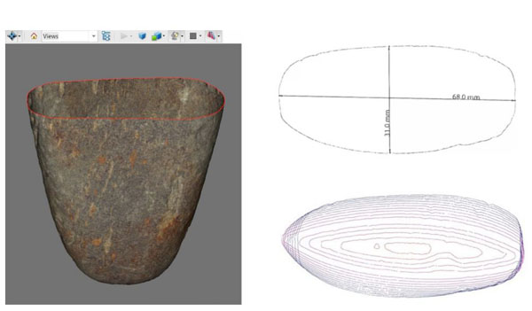
Portable 3D laser scanners are a valuable tool for compiling elaborate digital collections of archaeological objects and analysing the shapes and dimensions of pieces. Although low-cost desktop 3D laser scanners have powerful capacities, it is important to know their limitations. This paper performs an analysis of the uncertainty and repeatability of the NextEngineTM portable low-cost 3D laser scanner by scanning an object 20 times in two different resolution modes-Macro and Wide. Some dimensions of the object were measured using a digital calliper, and these results were used as the "true" or control data. In comparing the true and the scanned data, we verified that the mean uncertainty in the Macro Mode is approximately half that of the Wide Mode, at ±0.81 mm and ±1.66 mm, respectively. These experimental results are significantly higher than the accuracy specifications provided by the manufacturer. An analysis of repeatability shows that the successive replicates do not match in the same position. The results are better in Macro Mode than in Wide Mode; it is observed that the repeatability factor is slightly larger than the corresponding mode accuracy, with ±0.84 vs. ±0.81 mm in Macro Mode and ±1.82 vs. ±1.66 mm in Wide Mode. We suggest several improvements, such as adding an external reference scale or providing a calibrated object to allow for a self-calibration operation of the scanner.
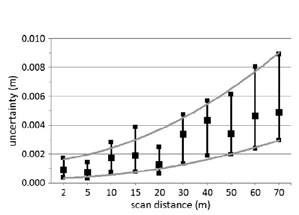
At present, several papers discuss the accuracy and precision of terrestrial laser scanners (TLSs), but the research continues to focus on the behavior of the TLSs. The purpose of this paper is to propose a method to evaluate the uncertainty of a TLS (FARO Photon 80). A rigid and transportable aluminum structure with 28 black-and-white targets was designed for this purpose. The structure was scanned 12 times at several distances from 2 to 70 m, and the x, y , and z coordinates of the center of the targets were automatically identified. Data were analyzed by means of circular and spherical statistics using R modules programmed in our research group. Analysis reveals that 3-D spatial distribution has a stratified pattern in the Z-axis. Regardless of the scanner status, these results indicate that these analyses should be performed periodically because they can have an impact on some studies. The proposed methodology is robust and simple and can be performed with free software such as the R modules used in this work.
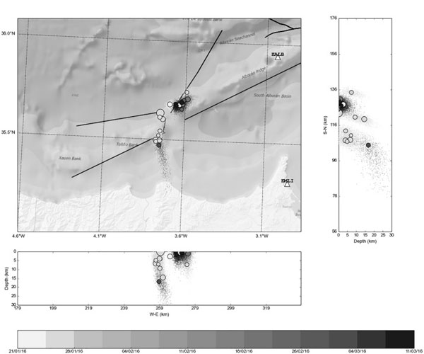
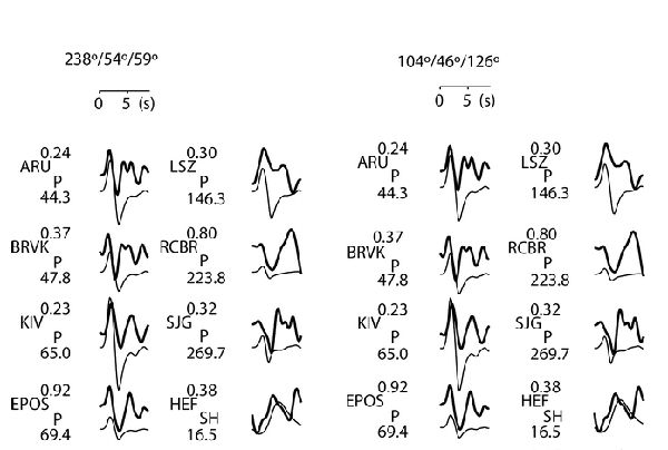
The Cape Saint Vincent region is of major seismological interest for its tectonic complexity and for the occurrence of the great 1755 Lisbon earthquake. No structure capable of generating such a large earthquake has yet been convincingly identified, but all authors agree that there is a possibility of a similar earthquake occurring offshore of the Cape sometime in the future. To shed some light on the region's dynamics, we here examine the mechanism of the three largest earthquakes to have occurred in the last 40 years west of the Cape – 29 July 2003 (Mw = 5.3), 12 February 2007 (Mw = 6.1), and 17 December 2009 (Mw = 5.5). By inversion of the body waves and the kinematic slip distribution, we estimated the three earthquakes to have had similar characteristics (dimensions, maximum slip, stress drop, source time function, focal depth, and rupture velocity), although there were differences in the geometry of the rupture that reflect the great seismotectonic complexity of the zone. The focal mechanisms of the 2003 and 2007 earthquakes were similar, corresponding to thrusting motion, but the 2009 earthquake had a dip-slip motion in a vertical plane. As deduced from the slip distributions, the three shocks show NE–SW rupture planes, with the energy released propagating to the NE, compatible with the regional NW–SE horizontal compression produced by the convergence of the Eurasian and African plates. Applied to the generation of the 1755 Lisbon earthquake, this direction of faulting would correspond to a complex rupture along NE–SW trending thrust faults at the Gorringe Bank, the Horseshoe Scarp, and the Marquis de Pombal Fault, with the rupture propagating to the NE towards the Portuguese coast. Such a model could explain that unusually large and tsunami-generating earthquake.
Aim The presence‐only data stored in natural history collections is the most important source of information available regarding the distribution of organisms. These data and profile techniques can be used to generate species distribution models (SDMs), but pseudo‐absences must be generated to use group discriminative techniques. In this study, we evaluated whether the SDMs generated with pseudo‐absences are reliable and also if there are differences in the results obtained with profile and group discriminative techniques.
Location Ecuador, South America.
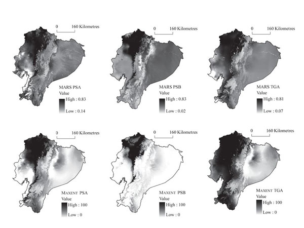
Methods The SDMs were generated with a training data set for each of the five species of Anthurium and six different methods: two profile techniques (BIOCLIM and Gower’s distance index), three group discriminative techniques [logistic multiple regression (LMR), multivariate adaptative regression splines (MARS) and Maxent] and a mixed modelling approach genetic algorithm for rule‐set production (GARP), which employs a combination of profile and group discriminative techniques and generates its own pseudo‐absences. For LMR, MARS and Maxent, three types of absences were generated: (1) random pseudo‐absences in equal number to presences and excluding a buffer area around presences (except for Maxent, which assumes that this background sample includes presences), (2) a large number (10,000) of random pseudo‐absences, also excluding a buffer area around each presence and (3) ‘target‐group absences’ (TGA), consisting of sites where other species of the group have been collected by the specialist, but not the species being modelled. To compare the predictive performance of the SDMs, the area under the curve statistic was calculated using an independent testing data set for each species.
Results MARS, Maxent and LMR produce better results than the profile techniques. The models created with TGA are generally more accurate than those generated with pseudo‐absences.
Main conclusions The advantages and disadvantages of different options for using pseudo‐absences and TGA with profile and group discriminative modelling techniques are explained and recommendations are made for the future.
Texto completo.
Three-dimensional (3-D) laser scanners build 3-D models of objects and have direct application in the cataloging of artifacts and in archaeological documentation. Certain low-cost scanners are suitable for small objects because the scanners have high accuracy and the ability to capture color and textures. This paper provides the workflow and the steps needed to scan small objects using a low-cost scanner, to build textured 3-D models, and to transmit these models embedded in portable document format (PDF) files. The proposed procedure permits interaction with objects in various ways, including making measurements and building sections. The results enable the dissemination of high-precision interactive models, readable with free software, thereby facilitating the study of the metric and morphological features of archaeological objects.
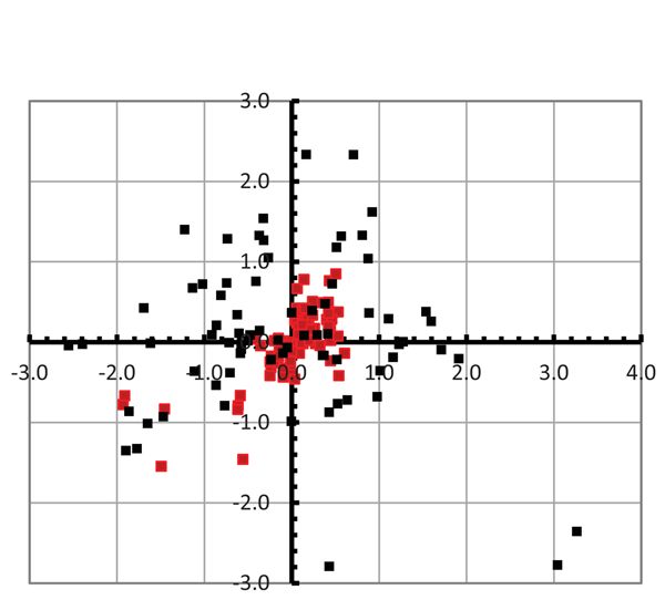
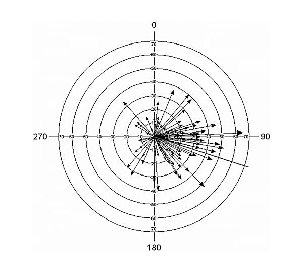
The positional error in spatial data is defined as a vector by comparing the coordinates between the true position and the measured position. The standard tests to assess the positional accuracy use only the magnitude of the vector and omit the azimuth. This article suggests that the use of both values allows a much more complete analysis of the positional error. A set of tests is proposed that are relevant for this purpose and demonstrate that some important features are not identified by the common procedures. The test samples come from two datasets. The first is obtained from the comparison of 100 homologous points in two conventional maps, and the second one comes from the geometric calibration of a photogrammetric scanner. The results are analyzed and discussed, showing that important issues such as error anisotropy are detected only by means of the circular statistics tests and density maps of distribution. Therefore, tests that assess the goodness of fit for uniform distribution in azimuths, such as Rayleigh and Rao tests, give low probabilities (P = 0 and P > 0.01). Moreover, density maps working with both magnitude and angle can locate the outlier candidate and offer more information about the spatial distribution of error.
Question: What are the effects of the number of presences on models generated with multivariate adaptive regression splines (MARS)? Do these effects vary with data quality and quantity and species ecology?
Location: Spain and Ecuador.
Methods: We used two data sets: (1) two trees from Spain, representing high‐occurrence number data sets with real absences and unbalanced prevalence; (2) two herbs from Ecuador, representing low‐occurrence number data sets without real absences and balanced prevalence. For model quality, we used two different measures: reliability and stability. For each sample size, different replicates were generated at random and then used to generate a consensus model.
Results: Model reliability and stability decrease with sample size. Optimal minimum sample size varies depending on many factors, many of which are unknown. Regional niche variation and ecological heterogeneity are critical.
Conclusions: (1) Model predictive power improves greatly with more than 18‐20 presences. (2) Model reliability depends on data quantity and quality as well as species ecological characteristics. (3) Depending on the number of presences in the data set, investigators must carefully distinguish between models that should be treated with skepticism and those whose predictions can be applied with reasonable confidence. (4) For species combining few initial presences and wide environmental range variation, it is advisable to generate several replicate models that partition the initial data and generate a consensus model. (5) Models of species with a narrow environmental range variation can be highly stable and reliable, even when generated with few presences.
Texto completo.
El conocimiento científico avanza a través de hipótesis que se van confirmando o se rechazan en el crisol de la experimentación. Pero abundan las hipótesis que, sin estar contrastadas, han generado numerosos estudios. Las causas son diversas: la complejidad del fenómeno, la escala espacial y temporal o la simple falta de datos. Hace unos años nos planteamos abordar una de esas cuestiones sin contrastar. El problema, aunque debatido durante más de 150 años, carecía de soporte empírico: ¿a qué se debe la semejanza o diferencia de las floras observadas en diferentes lugares del planeta? Si examinamos la composición florística de distintos lugares del mundo encontramos parecidos y diferencias. Algunas áreas comparten la mayoría de las especies; otras, presentan una composición específica distinta del resto...
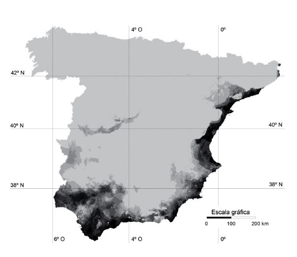
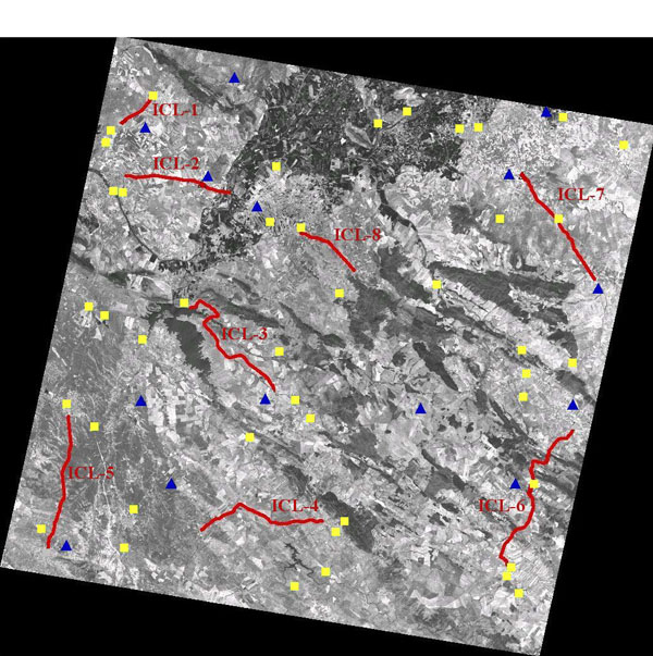
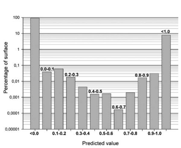
Gully erosion has been recognized as an important soil degradation process in rangelands of southwest Spain. In this paper, a relatively new data mining technique called Multivariate Adaptive Regression Splines (MARS) was applied to construct a model capable of predicting the location of gullies. A large database was used to support the model composed of a target variable (presence or absence of gullies) and 36 independent variables related to topography, lithology, soils, rainfall, land use and vegetation cover. The performance of the model was evaluated using the Receiver Operating Characteristic (ROC) curve for five external datasets. The model had high predictive power, with values for the area under the ROC curve of the external validation datasets varying from 0·75 to 0·98 (1·0 being perfect prediction). The most important variables explaining the spatial distribution of gullies were lithology and soil type. Finally the model was compiled and implemented into a geographical information system to obtain maps of susceptible areas for gully erosion. These maps show that approximately 7% of the study area presents favourable conditions for the development of gullies. The results demonstrate that MARS constitutes a valuable model in geomorphic research and could also be a useful tool for assessing the impacts of changing climate and land use on gully erosion. Copyright © 2009 John Wiley & Sons, Ltd.
To test the potential effects of winds on the migratory detours of shearwaters, transequatorial migrations of 3 shearwaters, the Manx Puffin us puffinus, the Cory's Calonectris diomedea, and the Cape Verde C. edwardsii shearwaters were tracked using geolocators. Concurrent data on the direction and strength of winds were obtained from the NASA SeaWinds scatterometer to calculate daily impedance models reflecting the resistance of sea surface winds to the shearwater movements. From these models we estimated relative wind-mediated costs for the observed synthesis pathway obtained from tracked birds, for the shortest distance pathway and for other simulated alternative pathways for every day of the migration period. We also estimated daily trajectories of the minimum cost pathway and compared distance and relative costs of all pathways. Shearwaters followed 26 to 52% longer pathways than the shortest distance path. In general, estimated wind-mediated costs of both observed synthesis and simulated alternative pathways were strongly dependent on the date of departure. Costs of observed synthesis pathways were about 15% greater than the synthesis pathway with the minimum cost, but, in the Cory's and the Cape Verde shearwaters, these pathways were on average 15 to 20% shorter in distance, suggesting the extra costs of the observed pathways are compensated by saving about 2 travelling days. In Manx shearwaters, however, the distance of the observed synthesis pathway was 25% longer than that of the lowest cost synthesis pathway, probably because birds avoided shorter but potentially more turbulent pathways. Our results suggest that winds are a major determinant of the migratory routes of seabirds.
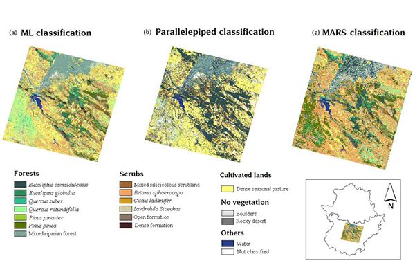
This work proposes a new method to classify multi-spectral satellite images based on multivariate adaptive regression splines (MARS) and compares this classification system with the more common parallelepiped and maximum likelihood (ML) methods. We apply the classification methods to the land cover classification of a test zone located in southwestern Spain. The basis of the MARS method and its associated procedures are explained in detail, and the area under the ROC curve (AUC) is compared for the three methods. The results show that the MARS method provides better results than the parallelepiped method in all cases, and it provides better results than the maximum likelihood method in 13 cases out of 17. These results demonstrate that the MARS method can be used in isolation or in combination with other methods to improve the accuracy of soil cover classification. The improvement is statistically significant according to the Wilcoxon signed rank test.
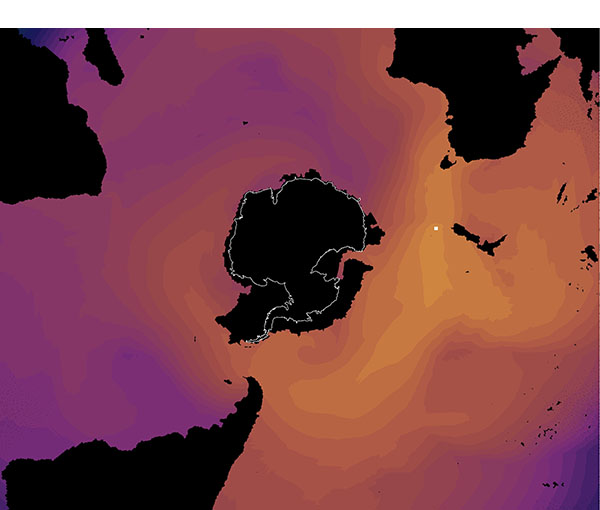
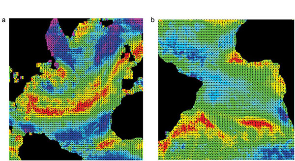
Global wind patterns influence dispersal and migration processes of aerial organisms, propagules and particles, which ultimately could determine the dynamics of colonizations, invasions or spread of pathogens. However, studying how wind-mediated movements actually happen has been hampered so far by the lack of high resolution global wind data as well as the impossibility to track aerial movements. Using concurrent data on winds and actual pathways of a tracked seabird, here we show that oceanic winds define spatiotemporal pathways and barriers for large-scale aerial movements. We obtained wind data from NASA SeaWinds scatterometer to calculate wind cost ( impedance) models reflecting the resistance to the aerial movement near the ocean surface. We also tracked the movements of a model organism, the Cory's shearwater (Calonectris diomedea), a pelagic bird known to perform long distance migrations. Cost models revealed that distant areas can be connected through "wind highways'' that do not match the shortest great circle routes. Bird routes closely followed the low-cost "wind-highways'' linking breeding and wintering areas. In addition, we found that a potential barrier, the near surface westerlies in the Atlantic sector of the Intertropical Convergence Zone (ITCZ), temporally hindered meridional trans-equatorial movements. Once the westerlies vanished, birds crossed the ITCZ to their winter quarters. This study provides a novel approach to investigate wind-mediated movements in oceanic environments and shows that large-scale migration and dispersal processes over the oceans can be largely driven by spatiotemporal wind patterns.
The dimensions and rupture velocities of four earthquakes, two in the Mid-Atlantic Ridge and two in Iceland with strike–slip mechanisms and magnitudes (Mw) between 6.2 and 6.8 were studied using the directivity effects of Rayleigh and body waves. For Rayleigh waves we used the directivity function for different pairs of stations and for body waves the waveforms of P and SH waves corresponding to a simple extended line source. We have found that three have very shallow depths about 3 km and one 8 km, fault lengths between 12 km and 21 km, and a low rupture velocity of about 1.5 km/s to 2.0 km/s which supports the idea of the presence of slow earthquakes in transform faults.
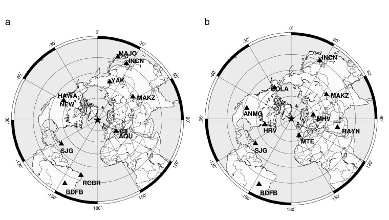
The deep earthquake (h = 650 km) that occurred on 11 April 2010 south of Granada, Spain, has been studied using the inversion of body waves at teleseismic and regional distances. We have obtained a solution of dip-slip motion on either a vertical plane or a nearly horizontal plane with the pressure axis dipping 45 degrees to the east. The horizontal plane is chosen as the rupture plane, with rupture propagating from east to west on the basis of directivity effects at teleseismic distances and differences of the waveforms at regional distances. The comparison of these results with the focal mechanisms of four other deep earthquakes that occurred in the same area shows similar rupture processes. The origin of this deep seismic activity remains an open question. Tomographic studies have shown the existence of an anomalous body in this region that extends from 200- to 700-km depth. The olivine-spinel phase transitions or shear melting along horizontal planes inside of this body may be an explanation for the occurrence of these earthquakes.
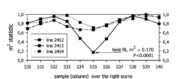
Remote sensors have begun to capture digital stereoscopic data. Although still monospectral (usually panchromatic), the capture of multispectral or hyperspectral stereoscopic data is just a matter of time. Digital photogrammetric workstations use area-based stereo-matching techniques based on the Pearson (product-moment) correlation coefficient. This is a technique that is not intended to take advantage of the multispectral data. The authors propose a new method that 1) can handle this multispectral information and 2) can take advantage of the spatial relations between pixel locations. The method is based on multidimensional scaling and Procrustes analysis. Our results indicate that the proposed new technique renders more robust results than classical methodology when noise in the original data is introduced.
The clearing of forests to obtain land for pasture and agriculture and the replacement of autochthonous species by other faster-growing varieties of trees for timber have both led to the loss of vast areas of forest worldwide. At present, many developed countries are attempting to reverse these effects, establishing policies for the restoration of older woodland systems. Reforestation is a complex matter, planned and carried out by experts who need objective information regarding the type of forest that can be sustained in each area. This information is obtained by drawing up feasibility models constructed using statistical methods that make use of the information provided by morphological and environmental variables (height, gradient, rainfall, etc.) that partially condition the presence or absence of a specific kind of forestation in an area. The aim of this work is to construct a set of feasibility models for woodland located in the basin of the River Liebana (NW Spain), to serve as a support tool for the experts entrusted with carrying out the reforestation project. The techniques used are multilayer perceptron neural networks and support vector machines. Their results will be compared to the results obtained by traditional techniques (such as discriminant analysis and logistic regression) by measuring the degree of fit between each model and the existing distribution of woodlands. The interpretation and problems of the feasibility models are commented on in the Discussion section.
Anisotropic (direction-dependent) long-distance dispersal (LDD) by wind has been invoked to explain the strong floristic affinities shared among landmasses in the Southern Hemisphere. Its contribution has not yet been systematically tested because of the previous lack of global data on winds. We used global winds coverage from the National Aeronautics and Space Administration SeaWinds scatterometer to test whether floristic similarities of Southern Hemisphere moss, liverwort, lichen, and pteridophyte floras conform better with (i) the anisotropic LDD hypothesis, which predicts that connection by "wind highways" increases floristic similarities, or (ii) a direction-independent LDD hypothesis, which predicts that floristic similarities among sites increase with geographic proximity. We found a stronger correlation of floristic similarities with wind connectivity than with geographic proximities, which supports the idea that wind is a dispersal vehicle for many organisms in the Southern Hemisphere.
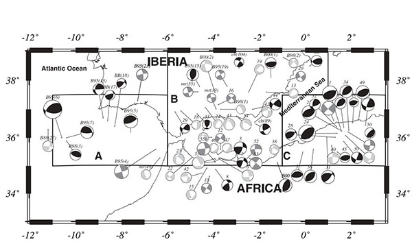
The plate boundary between Iberia and Africa has been studied using data on seismicity and focal mechanisms. The region has been divided into three areas: A; the Gulf of Cadiz; B, the Betics, Alboran Sea and northern Morocco; and C, Algeria. Seismicity shows a complex behavior, large shallow earthquakes (h < 30 km) occur in areas A and C and moderate shocks in area B; intermediate-depth activity (30 < h < 150 km) is located in area B; the depth earthquakes (h 650 km) are located to the south of Granada. Moment rate, slip velocity and b values have been estimated for shallow shocks, and show similar characteristics for the Gulf of Cadiz and Algeria, and quite different ones for the central region. Focal mechanisms of 80 selected shallow earthquakes (8 mb 4) show thrust faulting in the Gulf of Cadiz and Algeria with horizontal NNW-SSE compression, and normal faulting in the Alboran Sea with E-W extension. Focal mechanisms of 26 intermediate-depth earthquakes in the Alboran Sea display vertical motions, with a predominant plane trending E-W. Solutions for very deep shocks correspond to vertical dip-slip along N-S trends. Frohlich diagrams and seismic moment tensors show different behavior in the Gulf of Cadiz, Betic-Alboran Sea and northern Morocco, and northern Algeria for shallow events. The stress pattern of intermediate-depth and very deep earthquakes has different directions: vertical extension in the NW-SE direction for intermediate depth earthquakes, and tension and pressure axes dipping about 45 for very deep earthquakes. Regional stress pattern may result from the collision between the African plate and Iberia, with extension and subduction of lithospheric material in the Alboran Sea at intermediate depth. The very deep seismicity may be correlated with older subduction processes.
Logistic Multiple Regression, Principal Component Regression and Classification and Regression Tree Analysis (CART), commonly used in ecological modelling using GIS, are compared with a relatively new statistical technique, Multivariate Adaptive Regression Splines (MARS), to test their accuracy, reliability, implementation within GIS and ease of use. All were applied to the same two data sets, covering a wide range of conditions common in predictive modelling, namely geographical range, scale, nature of the predictors and sampling method. We ran two series of analyses to verify if model validation by an independent data set was required or cross-validation on a learning data set sufficed. Results show that validation by independent data sets is needed. Model accuracy was evaluated using the area under Receiver Operating Characteristics curve (AUC). This measure was used because it summarizes performance across all possible thresholds, and is independent of balance between classes. MARS and Regression Tree Analysis achieved the best prediction success, although the CART model was difficult to use for cartographic purposes due to the high model complexity.